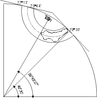
Fig. 1: Krovak projection
Geodetical Mapping - Krovak System
Doc. Dr. Vladimír Homola, Ph.D.
Krovak mapping is Gaussian equi-angular conic projection in the skew position. The Bessel ellipsoid is projected into the plain using the reference sphere. In Czechoslovakia, the Krovak mapping was established in 1922 for cadastral maps; later it was used for definitive military mapping. Since 1968, the sheets of Basic Map System of CZ are built in this projection.
Fig. 1: Krovak projection
The calculation of the projection is exceedingly difficult and is described in steps A to D.
The Bessel ellipsoid (parameters: a = 6377.397 [km], b = 6356.079 [km], f = 1/299.15, M0 = 6359.3926 [km], N0 = 6402.0861 [km]) is conformly displayed on the sphere with radius R0 = sqrt (M0 x N0) = 6380.7036 [km]; this ellipsoid touches the sphere in only one point. By this way, it is preserved the length of parallel with the geographical latitude j0 = 49.5 °; this parallel is displayed as the parallel of sphere with the sphere latitude U0 = 49.459957 °. The ratio of length preservation is
a = sin ( f0) / sin(U0) = 1.0005975.
The geographical longitudes l on ellipsoid correspond with the spherical longitudes V on sphere; there is V = a x l. The geographical latitudes are on principle related to Ferro meridian ( = 17° 40' West of Greenwich). The basic meridian is l0 = 42.5° [Ferro degrees]. For all points of grid, j and l must be transformed to U and V.
The U coordinate is given like U = ( b2 / a2 ) x tg j, or in this way:
DU" = 9985.859795 x D j + 2.402875 x D j2 - 0.011658 x D j3 + ...
where D j = j - j0 [in sec x 10-4]; then U = U0 + DU [in °]. In place of V coordinate, we search DV = a x (l0 - l).
The very open cone with l' = 352.98456° is put onto the sphere. The top of cone is about 131 [km] above the town Tallin. The constructive pole of cone is on jP = 59.7575 °, lP = 42.5°. The meridian lP = l0 is about 15 [km] from the end of the former Czechoslovak Republic east border (today's Carpathian Ukraine). To the coordinate jP (lP) corresponds the constructive coordinate UP = 59.711860° (ZP = 30.288140°) and DV = 0°.
The touch constructive parallel F0 = 78.5° with radius r0 = 1298.039 [km] conducts approximately along the middle of the mapped area (former Czechoslovak Republic). For all points of the grid, the spherical coordinates must be transformed to construction coordinates: U® D, DV ® L. The coordinate D can be calculated from Z = 90 ° - U according to cosinus rule, the coordinate L according to sinus rule:
cos
L = cos Z x cos ZP + sin Z x
sin ZP x cos
DV
sin
L = sin Z x sin
DV / sin
D
On account of decrease of the maximum length distortion (in place of 24 [cm/km] - 14 [cm/km] only), the radius of sphere is contracted by ratio 1.0001; new radius R = 6380.0655 [km]. For all points of grid, the polar coordinates can be calculated by transformation of construction coordinates according to Gauss conic mapping:
D0 =
90° -
F0
l' =
L x cos
D0
r = R x tg
D0 x (tg
(D/2) x cotg
(D0/2)) ^ (cos
D0)
The final step is the conversion of polar coordinates to rectangular coordinates (with exchange X and Y coordinate):
Y =
r x sin
l'
X =
r x cos
l'
The example for the point j = 49° 53' 29.1" and lFe = 32° 6' 10.5", i.e. lGr = 14° 26' 10.5":
| U = 49.850832° | DV = 10.403297° |
| D = 11.51291° | L = 35.68706° |
| l' = 39.97063° | r = 1299.478 [km] |
| X = 1064.852 [km] | Y = 744.804 [km] |